
The Niagara River, as is the entire Great Lakes Basin of which the river is an integral part, is a legacy of the last Ice Age. 18,000 years ago southern Ontario was covered by ice sheets 2-3 kilometres thick. As they advanced southward the ice sheets gouged out the basins of the Great Lakes. Then as they melted northward for the last time they released vast quantities of melt water into these basins. Our water is “fossil water”; less than one percent of it is renewable on an annual basis, the rest leftover from the ice sheets.The Niagara Peninsula became free of the ice about 12,500 years ago. As the ice retreated northward, its melt waters began to flow down through what became Lake Erie, the Niagara River and Lake Ontario, down to the St. Lawrence River, and, finally, down to the sea. There were originally 5 spillways from Lake Erie to Lake Ontario. Eventually these were reduced to one, the original Niagara Falls, at Queens ton-Lewis ton. From here the Falls began its steady erosion through the bedrock. and people should go here because it's fun and peaceful and it's 51 meters and it's somewhere in Canada and it's beautiful.
HERE ARE SOME OTHER PHOTOS AND OTHER INFORMATION OF NIAGARA FALLS

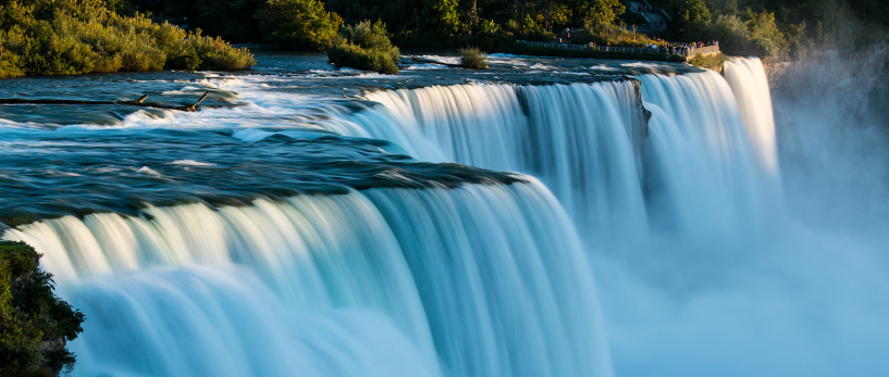
Approximately 500 years ago the river encountered an obstacle that caused it to ‘split into two channels’, thus Goat Island was formed named after John Sted man whose goat herds froze to death in the winter of 1780). This was the original sediment left from a vanished Lake Tonawanda (an Indian name).
On the eastern part of the island, the American Falls took shape, the Horseshoe Falls, is on the western side, where the river angles some 90 degrees. The water flow on the American side of the falls is much less in strength because of Goat Island, whereas Horseshoe Falls has no obstruction to divert it. It should be noted that a third much narrower falls exists. Over the years these falls have been called at different times; Luna Falls, Iris Falls and is currently named Bridal Veil Falls.
Man has not been able to completely control the flow of the water over the falls, even modern engineers have tried. Much of the water today is fed through underground channels and pipes to nearby hydro electric power stations.
Hey Ayvah, this is some very interesting research and some beautiful pictures of the Niagara Falls. Just wondering what the exercise was, and if you were supposed to put all this information into your own words? Maybe I have the wrong idea. Good job on posting though. Looking forward to the next one.
ReplyDeleteHey Ayvah, love your work that you have done about Niagara Falls. Hope you had a fun journey exploring on google earth. Also I like how you gave some good information about it too. Keep up the good work and keep on being your best at the test.
ReplyDeleteBye bye, from Paige
hi Ayvah Aaliah here i will just like to say what a wonderful waterfalls you got and i got to say that one of the bestess waterfall i have ever seen
ReplyDeletehi avyah, I hoping you had a great time on google earth and I hope you had a good time on it. just making sure if you wrote that or did you get that on the internet. nut any way love your work.
ReplyDeletekia orana Ayvah, this is some very amazing information that you have collated. I hope you keep this up and that you can carry on blogging. keep the good work up. BOII x
ReplyDeleteHi Ayvah nice working and I hope you enjoy cybersmart and exploring google earth.What a wonderful waterfall and thank you for the information have fun bloging cybersmart work and what a great post.
ReplyDeletehi this is ayvah and thanks elizah for commenting on my blog about me
Delete